The Lab Projects About Collaborate
Open the Paddler Map →
Live floatability for the Buffalo National River
Tale Waters & Tides/Projects/Buffalo National River
The Lab · Latest Beta

Paddler intelligence for America's first National River.

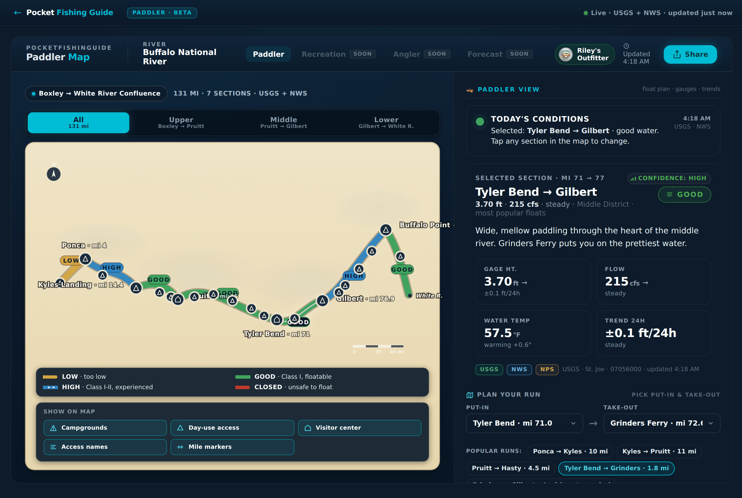
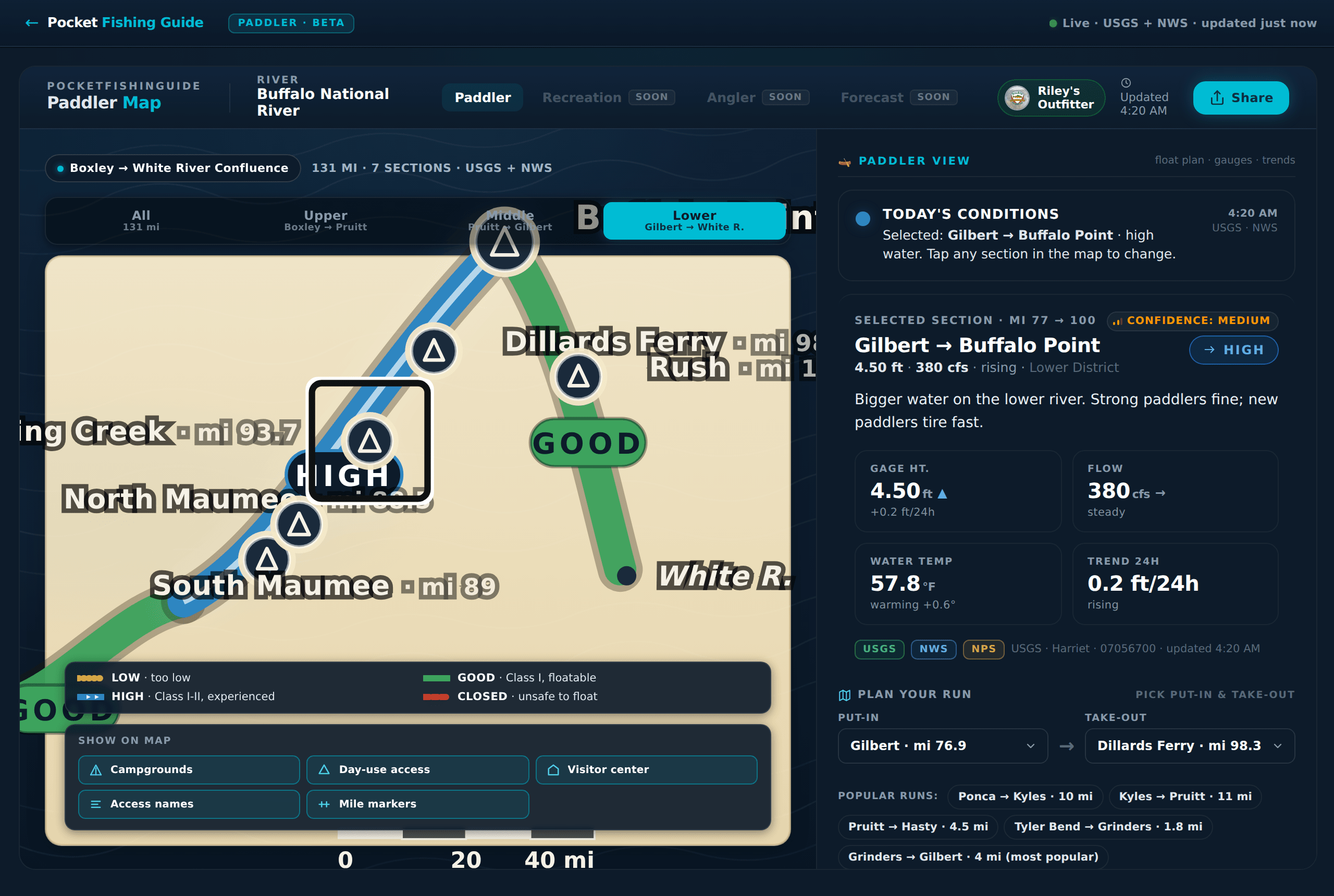
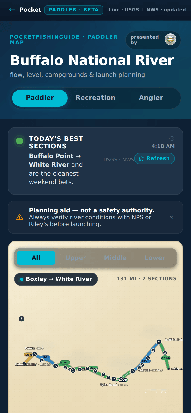
A mobile-first conditions dashboard built for paddlers, anglers, tourists, and the outfitters who serve them. Live USGS floatability per section, 7-day water-level trends, plain-English river reads, and a co-branded operator showcase — all on one screen, in one glance, in plain Arkansan.

LIVEBETABuilt with Riley's Outfitter
Open the Paddler Map →
Buffalo National River Paddler Map — desktop view showing color-coded floatability across seven river sections, today's conditions, live USGS gauge, water temperature, 24-hour trend, and plan-your-run controls.
What it solves

Five outfitter websites. Three USGS gauges. One paddler trying to decide if Saturday's float is on.

The Buffalo runs 153 miles through three districts — Upper, Middle, and Lower — each with its own gauges, its own access points, its own seasonal personality. Today, a paddler planning a weekend has to cross-reference raw cfs from three USGS sites, hunt for NPS regs, call an outfitter for their take, and still guess whether the section they want is too low, too pushy, or just right.

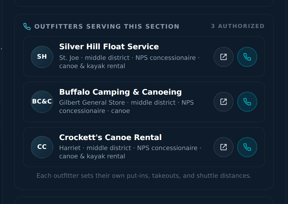
The Paddler Map collapses all of that into a single live view. Color-coded floatability per section. A plain-English read for each gauge. 7-day water-level and temperature trends. NPS & AGFC regs at every access. And a co-branded outfitter showcase so the operators who keep the river running get featured, not buried.

What's unique

Six things that don't exist anywhere else on the Buffalo.

Live floatability per section
USGS feeds for every reach, translated into a color band on the river: too low, runnable, pushy, closed. Not raw numbers — an answer.
7-day water level & temperature trend
Rising or falling? Warming or cooling? Two charts, one glance. Plan tomorrow's float around today's direction.
Plain-English river reads
“She's at a friendly 4.1 and dropping — easy Class I cruise, bring a fishing rod.” Deterministic, no LLM required, written like the river guide your uncle wishes he was.
Outfitter showcase mode
Authorized operators get a co-branded panel with a logo, contact tap, and a popular-runs list per section — built so Riley's and friends keep their voice on the river.
NPS regs & AGFC fishing intel
Camping rules, day-use rules, life-jacket law, smallmouth slot limits — surfaced inline at the access where you actually need them.
Spawn-phase intel for anglers
Layered on top of the PFG data engine: smallmouth bass spawn phase per section, water temp targets, and what the bite should be doing this week.
In the wild

Screen grabs from the live Beta.

Lower-district section sheet on the Paddler Map showing Gilbert to Buffalo Point reach, gauge 4.50 ft, 380 cfs, water temp 57.8 degrees warming, 24-hour trend rising 0.2 ft, status HIGH with medium confidence, and the river read: 'Bigger water on the lower river. Strong paddlers fine; new paddlers tire fast.'
Switch districts, tap a section, and the right-side panel rewrites itself — live cfs, water temp, trend direction, confidence, and a written read.
Outfitter showcase panel listing Silver Hill Float Service, Buffalo Camping and Canoeing, and Crockett's Canoe Rental with logo avatars, district, NPS concessionaire tags, and tap-to-call buttons.
Outfitters serving the selected section, surfaced inline. NPS concessionaire badging, tap-to-call, tap-to-visit — no scrolling, no Googling.
Mobile view of the Paddler Map at 390 pixels wide showing Buffalo National River header, mode toggle for Paddler / Recreation / Angler, today's best sections panel highlighting Buffalo Point to White River, a safety note, and the district pill row above the map.
Phone-first. Built for the put-in parking lot, not the desktop. 390×844, touch-sized targets, the same live data.
Desktop view of the Buffalo National River Paddler Map with section bands color-coded along the river, plan-your-run controls, popular run list, and the Riley's Outfitter co-brand badge top-right.
Desktop view — the operator showcase, the legend, and the plan-your-run picker, all without leaving the map.
Who it's for

Locals, tourists, and the outfitters keeping the river running.

The local
“Is Saturday on?”
Weekend paddlers in Marshall, Jasper, Yellville, and Mountain Home need one glanceable answer before they commit a Saturday and a shuttle ride.
The tourist
“What's a safe first float?”
Visitors from Little Rock, Memphis, Tulsa, and St. Louis arrive without local intuition. The map gives them district, mileage, difficulty, and an outfitter on the same screen.
The outfitter
“Send people, not phone calls.”
Operators like Riley's get a co-branded conditions view they can link from their own site — one source of truth, fewer “is the river running?” calls, more booked floats.
How it was built

Native AI in co-design and development.

The Paddler Map is the first lab product we shipped end-to-end on our AI-native pipeline: agents handle scoping, UX critique, and the build itself; humans hold the approval gate and the relationship with the river community. The same SOP that ships PFG ships this.

Riley's Outfitter sat in the room (virtually) as design partner — their put-ins, their runs, their phrasing of “is the river up?” calibrated the floatability model and the river reads. The scoping doc, the UX heuristic review, and the risk register are all AI-authored and human-approved artifacts in the repo.

RoleOwnerOn this project
Scoping & UX designClaude (Claude Code)Feature scoping doc, persona model, floatability rubric, accessibility heuristic review
Code implementationCodexReact app, USGS / NWS data wiring, section-sheet UI, mobile responsive build
Release polish & reviewCopilotChangelog, PR-level review, copy nits, version pins
Approval & field validation@sirgaladad + Riley's OutfitterOperator sign-off, feature priority, real-river truth-checking
Open the live Paddler Map
Beta release — live USGS & NWS data on every section of the Buffalo. Built with Riley's Outfitter.
Launch the Map →